

Author: Denys Hubashov
Design: Nadja Kelm
Published: October 4, 2023.
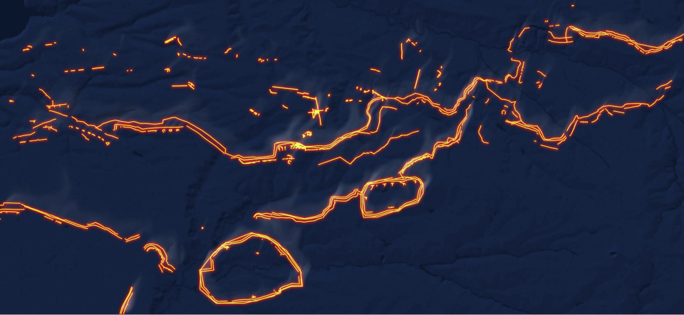
The TEXTY team reconstructed the Russian defense line in the south. We used satellite images dated June through September 2023 to trace changes to the fortifications built by the occupiers in the city of Tokmak which is still under Russia’s control and the villages of Robotyne and Verbove which had recently been liberated by the Ukrainian military.
Satellite imagery for the project was provided by Planet Labs
The liberation of Robotyne marked the beginning of the grand battle for Tokmak which might become the closing act of the 2023 military campaign.
Tokmak is the key to Melitopol, and the battle for this large city may turn into a tug of war for several months, but it will be the final strike in the cutting of the land corridor which connects the occupied Crimea to the occupied eastern regions.
This is a classic Soviet line of defense with massive kill zones to cross and a deep support line to penetrate with minefields, outposts, and observation stations.
The Russian defense system which has been built since the fall of 2022 includes hundreds of miles of continuous trenches, dugouts, pillboxes, earth-and-timber emplacements, strongpoints some of which as large as a medieval fort and able to hold for several days alone as well as sophisticated logistics, a system of small ammunition depots, and RI, UAV, and artillery rear bases.
The occupiers have deployed substantial reserves near Tokmak including the newly established 25th combined arms army and 76th and 7th airborne divisions. Those forces are currently attempting attacks on the flanks of the advancing elements of the Armed Forces of Ukraine.
We tried to at least partially show how Russian fortifications were built in the south. The defensive lines are strong, so it looks like their assault could drag on for months.
Informational partners:
The red zone on the map is the occupied territories
The strategic goal of the AFU is to reach the Azov sea coast. This would enable rupturing the communications and supply lines connecting the occupied east of Ukraine and the occupied Crimea. The liberation of Melitopol is an important step towards that goal. While pushing for the Azov sea, the AFU are attempting to maintain the front as broad as possible to defend it afterwards.
Ukraine is mounting an active offensive in the Tokmak area. The front line has already moved south toward the main line of the Russian defenses. In this area, the Russian fortifications comprise three main defense lines.
The supply (first) line is made of PS and CS defended by platoons and companies. The abbreviations stand for “platoon strongpoint” and “company strongpoint”. Those fortifications consisting of trenches and dugouts offer a certain level of autonomy. All the space between those fortifications all the way to the second line of defense is riddled with land mines. There are only a few supply roads which connect the strongpoints with the second line of defense. The supply line is intended to restrict the freedom of maneuver of the advancing troops as much as possible, to constrain their actions and to determine the direction of the offensive. This line is mostly defended by draftees and Storm Z units.
It is in front of the first line and between its fortifications that the largest minefields in Europe since the World War I have been laid.
Ukraine’s defenders were able to penetrate those minefields and the fortifications surrounding them and to breach the main line of defense in a number of places. Such were the dominant conclusion of the OSINT experts who monitor the fighting in the south after studying the photos of anti-tank ditches and tetrahedron obstacles.
The second line is the core of the defenses. It is built around a trench stretching for miles. It provides access to various fortifications such as sophisticated emplacements and heavy structures, concrete pillboxes, the previously mentioned PSs and CSs as well as large battalion-level fortifications built for a garrison of 500-600 people. Such fortifications have their own headquarters and depots which are mostly located in the nearest settlements. This line is defended by regular army units.
The third line consists of reserve positions to fall back to if the main line is breached. It also has fortifications and battalion-level depots. In addition to that, it contains various support facilities and units such as assigned repair workshops, intelligence support units, EW and SIGINT units, and headquarters of artillery units. It is here that reserve airborne units are stationed. They are tasked with repelling the attack of the advancing adversary at just the right time and mounting a counterattack.
It also contains fortifications near Tokmak and a large fortified area built in and around the village of Ocheretuvate.
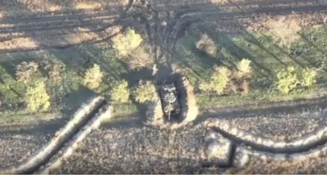
Let us look at the first line of the defense. This strongpoint is located between the village of Robotyne which was liberated at the beginning of September 2023 and Novoprokopivka. It might just be the focus of the current AFU assault.
The image shows a strongpoint of the first line. This fortification was built right in front of the Ukrainian positions. Judging by the size, the strongpoint is designed to hold a garrison of 200 people (i.e. a company). It has a sophisticated system of trenches, dugouts, and listening posts. It is likely surrounded with mine fields. The photo was taken in June 2023 — since then the fortification could only have been expanded. As at September 2023, that particular fortification is most likely to have been been captured by the AFU based on the information from DeepState website which tracks the front line changes. The image below provides a textbook illustration of a strongpoint designed to accommodate a rifle squad. Such strongpoints are usually combined into platoon strongpoints which are in turn combined into a company strongpoint.
There is a trench with rifle pits and covered firing ports.
As you can see, some of the trenches are covered with logs which provide additional shelter. On the western side, some 200 m of the trench appear to be covered. It might be presumed that such measures were taken to reduce the impact of munitions dropped from drones.
Trench overhead cover
The fortification also contains a protective shelter for vehicles which can also be used for storing ammunition or fuel.
Protective shelter for vehicles
The fortification is accessed via Robotyne-Novoprokopivka main road. There are also dirt roads which connect various parts of the fortification and provide access to other centers of resistance.
The surrounding area has been mined.
The absence of vehicle tracks on the fields surrounding the fortification suggests the presence of mine fields.
There are also "remote" observation points in this fortification. Rifle or gunnery positions are located somewhat far from the main trench - at a distance of about 70-90 m.
Forward rifle pits
All the vegetation in front of the fortification has been mowed as per the textbooks on military engineering.
There are many more fortifications like that along the entire front line. Our study was only focused on a small area near Tokmak where the Ukrainian offensive is currently underway.
The second and the third lines of defense are even more complex.
What makes this area stand out is an intermediate system of fortifications between the second and the third lines of defense.
Each line at least contains a anti-tank ditch, the Surovikin pyramids (also called ‘dragon teeth’) and the fortifications for military personnel.
The village of Ocheretuvate has separate lines of defense which consist of an anti-tank ditch, anti-tank pyramids and a number of strongpoints facing north.
A typical standalone strongpoint is shaped like the letter ‘T’ and has covered trenches which enable safe retreat, ammunition supplies and evacuation of the wounded. Based on the width of the frontal part of the strongpoint (350 m), this must be a platoon-level fortification.
T-shaped strongpoint
The area around Tokmak has its dedicated fortifications including anti-tank ditches, dragon teeth, trenches and dugouts.
The second line of defense is also represented by standalone engineering structures. For example, the photos of the areas towards Vasylivka show complex strongpoints. Such a strongpoint may be up to 500 m wide and up to 200 m deep.
There are also strongpoints closer to Vasylivka — first and foremost along Vasylivka-Tokmak road, one of the main supply routes of the Russian army at the line of engagement.
The part of the Tokmak road north of Solodka Balka is covered by a Russian battalion-level strongpoint. This formidable fortification is over 6 km wide. There is also an anti-tank ditch crossed by the Tokmak-Robotyne road.
It is followed by anti-tank pyramids made of concrete which are being heavily patrolled which is evident from the vehicle tracks along the ditch.
The fortifications themselves are next. They are quite sophisticated and consist of a variety of engineering structures.
Adjacent rifle pits
Some of the trenches have been converted into underground tunnels which provide shelter from artillery fire or attacks of drones carrying grenades or other free-fall munitions. Some permanent fortifications (e.g. pillboxes) are made of concrete.
The fortifications are very extensive and have covered pathways for rear access. Such trenches dug from the rear to the front line provide a certain degree of safety for the re-supply of ammunition, medical evacuation etc.
Trench with internal defense posts
There is a service area for unloading vehicles carrying ammunition directly behind the fortifications. However, there is not a single structure in sight near the fortifications since they are all hidden underground.
The photos also show dirt roads to various parts of the strongpoint with signs of active use.
The line of fortifications appears to be built to last and suggests plans for long-term defense. It has numerous firing points including machine-gun nests.
There is a tree belt covering the left flank of the position. While the trees provide cover for the trench, the firing points are positioned further forward.
There are also two outposts which may just as well be decoys.
The strongpoint also has numerous positions including protective shelters for vehicles. The images suggest that the strongpoint is being used by a mechanized brigade. Such protective shelters may contain tanks, armored personnel carriers and trucks.
Here is a typical tank shelter
The fortifications built to the north of Ilchenkove deserve a special mention. This is an outpost of the line of defense which was covered in detail above. The outpost covering the road is tasked with containing advancing AFU forces to win time. It appears to have been built according to Soviet military engineering textbooks.
For example, the textbook requires mowing the grass in front of the positions.
Here, the central trench, which allows quick transit from one edge of the positions to the other, has an 80 m long tunnel in one section.
The fortification has both open and covered firing points. Some of them may be used by machine gunners while others — by observers.
Rifle pit with covered firing port
There are also a number of protective shelters for vehicles.
The roads to the fortification appear to be frequently used. The access to the fortification is through a tree belt in the rear.
The tree belt also provides cover for a number of Russian military trucks.
The Russians also use the copse further north of the fortifications to hide their vehicles.
This fact is evident from the tracks on the dirt roads near the tree belt.
The area around the tree belt is riddled with shell craters.
The neighboring tree belt is also likely to be used to hide military vehicles, and it appears that Ukrainian artillery operators are well aware of the fact judging by the craters. This high-resolution image was taken in the period between June and July 2023.
At present, the Ukrainian military are storming Russian positions near Verbove.
They have already captured the positions to the north-east of the village.
According to Brigadier General Oleksandr Tarnavskyi, the commander of Tavria operational-strategic group, the Armed Forces of Ukraine made a breakthrough near Verbove. It might be assumed that the main battle has shifted to the Russian lines of defense.
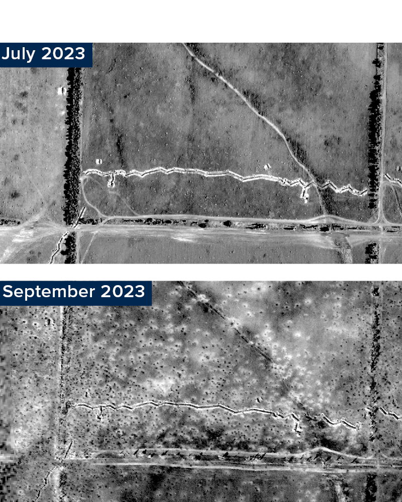
Russian positions before and during the counteroffensive
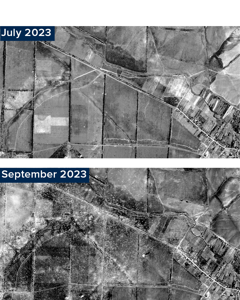
The above conclusions are based on the study of high-resolution satellite images of Russian positions dated June to July 2023. However, the images taken in September (albeit of poorer quality) show that the positions ceased to exist as they had been physically destroyed by artillery and MLRS fire.
Russian positions before and during the counteroffensive
You can navigate the map and zoom in and out to study the Russian positions.
Satellite cameras are very hard to avoid: even a low-spec computer with internet access is quite enough to access free satellite images and spot enemy positions.
The Ukrainian counteroffensive has been one of the most complex and the bloodiest military operations in Eastern Europe since World War II. Support the defense forces and help those who are fighting hard on the front lines.
